Photogrammetry drone - List of Manufacturers, Suppliers, Companies and Products | IPROS

Photogrammetry drone Product List

1~2 item / All 2 items

Displayed results

Domestic Drone: Aerobo PPK (AS-MC03-PPK)

2-frequency GNSS receiver equipped for post-processed kinematic surveying

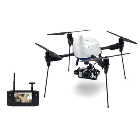
The "AeroBoo PPK" is a domestically developed drone specifically designed for photogrammetry, created to reduce the labor involved in installing ground control points during the photogrammetry process. It allows for photogrammetry to be conducted without the need to set up control points, making it particularly recommended for daily tasks such as "site progress management" and "volume inventory" in drone surveying. 【Features of the New AeroBoo PPK】 ■ Easy to use with simplicity ■ Suitable for surveying in hard-to-reach areas ■ Covers 10 hectares in one flight ■ Operates safely with fully automated flights *For more details, please refer to the PDF document or feel free to contact us.

  • Surveying
  • Other measuring instruments
  • Photogrammetry drone

Added to bookmarks

Bookmarks list

Bookmark has been removed

Bookmarks list

You can't add any more bookmarks

By registering as a member, you can increase the number of bookmarks you can save and organize them with labels.

Free membership registration

JC-STAR★1 compatible | Domestic photogrammetry drone "AeroBo PPK"

Supports dual-frequency GNSS and PPK positioning. A domestically produced photogrammetry drone that combines long-range communication and convenience.

The "AeroRob PPK (AS-MC03-PPKHL)" is a domestically produced photogrammetry drone equipped with a dual-frequency GNSS receiver, supporting post-processed kinematic (PPK) positioning. By accurately calculating the camera position at the time of shooting through PPK positioning, it reduces the need for setting up and surveying reference points, thereby streamlining fieldwork in photogrammetry. It is equipped with a Sony α6100 and a 3-axis gimbal. With the adoption of Herelink HD Transmission, it allows for flying while checking the drone camera's footage on a handheld control device, and it supports taking still images from any angle. By combining it with the GNSS ground marker "AeroRob Marker" and the photogrammetry analysis and data management system "AeroRob Cloud," it can enhance the efficiency of operations from aerial photography, PPK positioning, image analysis, to deliverable creation. Additionally, it has obtained the "JC-STAR Compliance Label★1," which visualizes security measures for IoT products. This can be used as information to verify compliance with security requirements when introducing or procuring commercial drones.

  • photograph
  • Photogrammetry drone

Added to bookmarks

Bookmarks list

Bookmark has been removed

Bookmarks list

You can't add any more bookmarks

By registering as a member, you can increase the number of bookmarks you can save and organize them with labels.

Free membership registration

Related Categories of Photogrammetry drone